
This year, as growers, water managers and rural communities in the West face record-setting drought, a unique public-private sector consortium launched a new online data tool called OpenET to enable more innovative water management strategies.
OpenET uses publicly available satellite and weather data to estimate evapotranspiration, or ET, down to the field level across 17 western states. For the first time, it brings together six independent models that estimate evapotranspiration onto a single platform that can be used by small and large growers and water managers alike, ultimately helping to build broader trust and agreement around this valuable information.
For most crops, evapotranspiration is a key measure of the amount of water that needs to be replaced through irrigation or precipitation during the growing season to ensure a well-watered, healthy crop with maximum yields.
Despite the importance of ET data, it was previously expensive, fragmented and not easily accessible. OpenET fills this major data gap in water management in the West. From OpenETdata.org, users can click on a field in the western United States and easily view and download monthly and annual ET data for the current year and previous five years at no charge.
From OpenETdata. org, users can click on a field in the western United States and easily view and download monthly and annual ET data for the current year and previous five years at no charge.
To provide the most accurate estimates possible, the project team has extensively compared OpenET data to ground-based measurements. The team also has worked with a wide variety of organizations to demonstrate how ET data can be used.
OpenET data can enable water and land managers to develop more accurate water budgets, water trading programs and other innovative programs as water supplies become increasingly scarce. For example, the Rosedale-Rio Bravo Water Storage District in the San Joaquin Valley, ground zero for groundwater overdraft in California, is using OpenET to provide near real-time information on water use in its open source online accounting and trading platform.
The platform enables a landowner to check on their water budget similar to how they would check an online bank account balance, and it allows staff to track the water budget of the entire district.
Access to ET data can significantly empower local communities to find their own best paths to water security and sustainability. For example, OpenET is being used in Kremmling, Colorado, to help inform and shape locally driven solutions to declining water supplies from the Colorado River.
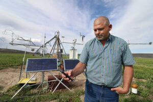
Working with several ranchers in Kremmling, a team of scientists, irrigators and conservation groups is using OpenET to evaluate the impacts of different irrigation and conservation practices on pastureland. They are comparing ET on parcels with normal versus deficit irrigation and combining that data with information on crop yield and revenue. The goal is to identify solutions that balance water supply and demand while supporting sustained agricultural production and a vibrant rural community.
OpenET will be adding daily ET data in the near future. Growers will be able to use daily ET data, once available, to gain a better understanding of water consumption on their fields and design more efficient irrigation systems. ET data is often most powerful in this context when integrated into software tools that help irrigators both track ET and account for other important factors that affect irrigation scheduling, including irrigation type and application rate, soil moisture, salinity management, and soil type and texture.
Field trials by the University of California Agriculture and Natural Resources, NASA and California State University Monterey Bay found that integrating ET data into these kinds of tools can help reduce applied water by between 15% and 40% while sustaining yields. That also can translate into savings on water conveyance and fertilizer costs.
OpenET has only been possible because of an unprecedented collaboration supported with public and philanthropic funding and input from more than 100 growers, water managers and other stakeholders. The project is led by NASA, Environmental Defense Fund, Desert Research Institute and HabitatSeven, along with numerous other additional team members.
For more information, go to https://openetdata.org


